
Step 6: Trace Someone's Atlantic Travels
Historical novels help us imagine the perspective of a person traveling in the Atlantic World, and it is also see how a person's specific travels fit into the geography of their era. For example, consider this map showing all of the places where Olaudah Equiano travelled in his lifetime. Click the map for a larger version.
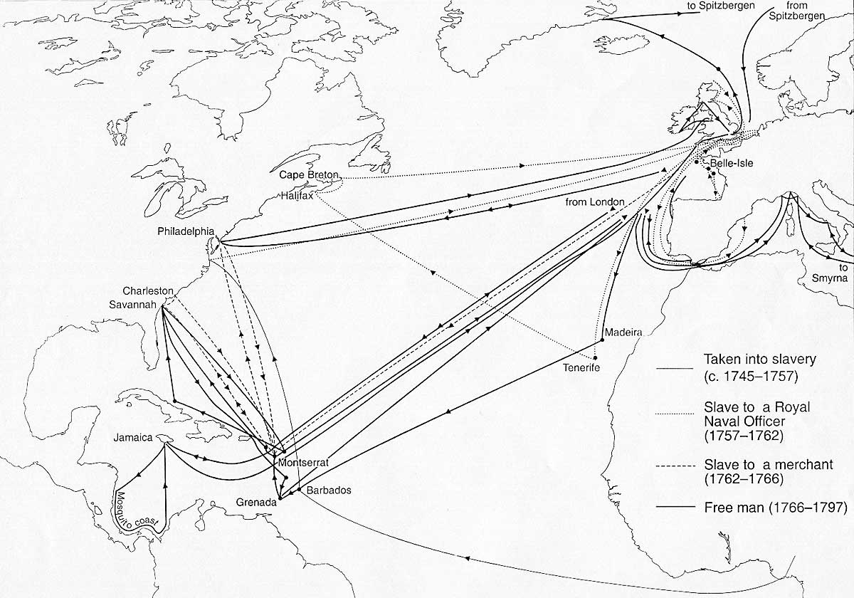
If you compare Equiano's travels with the triangular trade map from Step 4, you'll notice a similar pattern in both diagrams. Even before reading all of the details of his life, you can tell that Equiano's experiences as a Nigerian captive, a slave, a merchant sailor, and a leader of the British abolitionist movement kept him linked closely to mercantile trade patterns. Choose one of the other individuals featured in Step 2 and see what other conclusions you can draw about a traveler's life based on his or her destinations. Read that individual's biographical facts to figure out where they were from, what part of America they were living in at the time, and if that person's later travels are known. Then estimate where those places were located on this interactive historical map from the School Atlas of World History. Be sure to use the timeline at the bottom to set the map to the year 1750.
The school atlas map shows the basic outline of the continents, and the insets include the political boundaries for different eras. But national borders are not the only significant details that could be featured on a map. Try finding the same locations on the following historical maps to see how these places could be represented differently.
The Stevens-Brown Map/Orbis Typus Universalis, 1507-1513
Planisphere Physique, by Philippe Buache, 1757
Major Regions for Disembarkation of African Slaves, 1514-1866
Wind and Ocean Current Patterns, 1514-1866
Physikalischer Atlas (one of the first global disease maps), by Heinrich Berghaus, 1852
Each historical map compared locations based on a different theme, such as explorers' findings, important slave ports, weather conditions, and places where mosquito borne diseases were common. Such details were just as influential as imperial politics for the lifestyles (and death risks) of the people who lived there. For example, since schooner ships relied on wind to push the sails, the busiest ports were located in areas where the wind currents tended to blow towards the coast. Also, the Berghaus map indicates that people in West Africa and Brazil faced increased risk of "elephantiasis," a mosquito-borne disease that could cause disfigurement and liver damage. Like malaria and yellow fever, this disease became an epidemic in the Atlantic coastal regions of the West Indies and North America as infected mosquitoes spread it from people with previous exposure (West Africans). Consider this risk and other geographic factors as you rethink what you've learned about a specific Atlantic traveler. Finally, use the space below to write a thesis statement suggesting how the environment and geography of that person's destination may have complicated their experiences.
